.JPG "Exquisite Properties")


Mudumu National Park, Kongola, Namibia
Agent: Cliff Jacobs - Managing Principal Property Practitioner & CEO - Exquisite Hotel Consultants (Nat.Dpl.Hotel Man (UJ). M.P.R.E.)
Agent Cellphone: +27 (0) 84 413 1071 / +27 (0) 61 716 6951
Agent Office Number: +27 (0) 84 413 1071
Agent Email Address: cliff@exquisitehotelconsultants.com
Type: Game Lodges
Bedrooms: 24
Bathrooms: 24
Showers: 24
Parking: 30
Yield: Not Disclosed
Mudumu
Mudumu is a National Park in Caprivi Region in north-eastern Namibia. The park was established in 1990. It covers an area of 737 square kilometres (285 sq mi). The Kwando River forms the western border with Botswana. Various communal area conservancies and community forests surround Mudumu National Park.
The area is an important migration route from Botswana to Angola for large game species such as African elephant. There is no boundary fences, and Mudumu forms a crucial trans-boundary link for wildlife migration between Angola, Botswana, Namibia and Zambia. It is in the centre of Africa’s largest conservation area, the Kavango-Zambezi Trans-Frontier Conservation Area (KaZa TFCA).
History
Mudumu National Park was created in 1990, shortly before Namibia's independence. Although the approved size of the park is 1,010 square kilometres (390 sq mi), the actual size is 737 square kilometres (285 sq mi).
Climate
Average annual rainfall is between 550 millimetres (22 in) and 700 millimetres (28 in) per year, with the peak rainy period arriving in January and February. In years of heavy rainfall, flooding can be extensive, although Mudumu is drier than her sister park, Nkasa Rupara.
Geography and access
The Park is situated approximately 35 kilometres (22 mi) south of Kongola, bordered by Botswana to the west, and various communal area conservancies. The entire park is flat, with no hills or mountains. A fossilized river course - the Mudumu Mulapo – lies in the centre of the park. This is a seasonally dry, open channel that drains the primarily Mopane woodlands of the hinterland to the east. There is no formal entrance gate and the park is unfenced. A graded track, called a cutline, separates the park from neighbouring communal farmland. C49 (D3511) road runs through the park linking the villages of Kongola and Sangwali.
Biology and ecology
Mudumu National Park is situated in the tree and shrub savannah biome. Vegetation types are north-eastern Kalahari woodlands, riverine woodlands and islands, Caprivi mopane woodland and Caprivi floodplains. The Kwando River floodplain, grasslands, riparian woodlands and dense mopane woodland shelter woodland fauna and flora.
Flora
Mopane (Colophospermum mopane), wild syringa (Burkea africana), leadwood (Combretum imberbe) and mangosteen (Garcinia livingstonii) are common trees.
Fauna
Mudumu has a large African elephant population. Other animals include African buffalo, lion, leopard, spotted hyena, cheetah, African wild dog, hippopotamus, Nile crocodile, sitatunga, meerkat, red lechwe, sable antelope, Common eland, giraffe, impala, plains zebra, blue wildebeest and spotted-necked otter. There are no black or white rhinos in this park. Sable antelope, giraffe and eland were re-introduced into the area.
Tiger fish and tilapia are common fish species. 430 bird species have been recorded, including African fish eagle, African skimmer and western-banded snake eagle.
Fire
Natural fires caused by lightning and human-made fires burn large sections of the park each year. Firebreaks are made during the wet summer months. An early burning programme has been introduced in the dry winter months from May–July.
Recreation
Walking, bird watching and game viewing are the main tourism activities.
The Namibian Government has divided the park into various areas, called concessions. These create zones for various activities. Two privately managed lodges are in the park.
No permits are needed for travelling on the C49 road that connects the villages of Kongola and Lizauli. Permits are required on all other roads and tracks within the park. Most roads require four-wheel drive vehicles. During the rainy season from November to April it is recommended to drive in a convoy of at least two vehicles.
Mudumu is located within a high-risk malaria area.
Kavango-Zambezi Trans-frontier Conservation Area
Angola, Botswana, Namibia, Zambia and Zimbabwe have agreed to manage trans-boundary conservation through the Kavango–Zambezi Trans-frontier Conservation Area (KaZa TFCA). Mudumu is situated in the centre of the Kaza TFCA and forms a corridor for elephant, buffalo, roan and sable antelope movement from Botswana into Angola and Zambia.
KaZa includes numerous proclaimed national parks (including Mudumu), game reserves, community conservation areas, forest reserves, and iconic tourism destinations such as the Victoria Falls and Okavango Delta. KaZa aims to broaden the protected areas network, increase biodiversity, expand historical game migration routes and attract tourists to the area.
In a place where local people often bear the costs of living with wildlife, KaZa aims to make the protection of wildlife and wild places economically more attractive to rural communities.
Park Management
Mudumu National Park is one of five national parks in north-eastern Namibia. It is managed as a unit with Bwabwata National Park, Khaudom National Park, Mangetti National Park and Nkasa Lupala (formerly Mamili National Park). Since 2006, the NamParks Project (formerly BMM Parks Project), co-funded by the Federal Republic of Germany through KfW, has helped develop these parks.
Funding has been used to set up tourism, business and management plans, improve infrastructure, translocate animals back into their natural habitat and develop partnerships between Government and communities to manage parks with other land units.
Mudumu National Park forms part of the Mudumu North and Mudumu South complexes. Complexes group formally protected areas, conservancies and forestry management areas into single units to manage resources across park and conservancy boundaries. Stakeholders work together on law enforcement and anti-poaching, fire management (early burning), game monitoring and wildlife translocations. This approach is known as integrated park management.
The Ngenda Ranger Station is the park headquarters. Staff offices, entrance gates and housing were built as part of the cooperation.
NamParks has helped introduce park-friendly land-uses in the surrounding areas and collaborative management structures.
Mudumu serves as a core wildlife area, supplying wildlife to neighbouring conservancies that can encourage tourists. Trophy-hunting is practiced in the park under strict conditions.
Namibia
Namibia, officially the Republic of Namibia, is a country in Southern Africa. Its western border is the Atlantic Ocean. It shares land borders with Zambia and Angola to the north, Botswana to the east and South Africa to the south and east. Although it does not border Zimbabwe, less than 200 metres (660 feet) of the Botswanan right bank of the Zambezi River separates the two countries. Namibia gained independence from South Africa on 21 March 1990, following the Namibian War of Independence. Its capital and largest city is Windhoek. Namibia is a member state of the United Nations (UN), the Southern African Development Community (SADC), the African Union (AU) and the Commonwealth of Nations.
The driest country in sub-Saharan Africa. Namibia has been inhabited since pre-historic times by the San, Damara and Nama people. Around the 14th century, immigrating Bantu peoples arrived as part of the Bantu expansion. Since then, the Bantu groups, the largest being the Ovambo, have dominated the population of the country; since the late 19th century, they have constituted a majority. Today Namibia is one of the least densely populated countries in the world.
It has a population of 2.55 million people and is a stable multi-party parliamentary democracy. Agriculture, tourism and the mining industry – including mining for gem diamonds, uranium, gold, silver and base metals – form the basis of its economy, while the manufacturing sector is comparatively small.
In 1884, the German Empire established rule over most of the territory, forming a colony known as German South West Africa. Between 1904 and 1908, it perpetrated a genocide against the Herero and Nama people. German rule ended in 1915 with a defeat by South African forces. In 1920, after the end of World War I, the League of Nations mandated administration of the colony to South Africa. As mandatory power, South Africa imposed its laws, including racial classifications and rules. From 1948, with the National Party elected to power, this included South Africa applying apartheid to what was then known as South West Africa. In the later 20th century, uprisings and demands for political representation by native African political activists seeking independence resulted in the UN assuming direct responsibility over the territory in 1966, but the country of South Africa maintained de facto rule. In 1973, the UN recognised the South West Africa People's Organisation (SWAPO) as the official representative of the Namibian people. Following continued guerrilla warfare, Namibia obtained independence in 1990. However, Walvis Bay and the Penguin Islands remained under South African control until 1994.
Etymology
The name of the country is derived from the Namib desert, the oldest desert in the world. The name Namib itself is of Nama origin and means "vast place". That word for the country was chosen by Mburumba Kerina, who originally proposed the name the "Republic of Namib". Before its independence in 1990, the area was known first as German South-West Africa (Deutsch-Südwestafrika), then as South West Africa, reflecting the colonial occupation by the Germans and South Africans.
At 825,615 km2 (318,772 sq mi), Namibia is the world's thirty-fourth largest country (after Venezuela). It lies mostly between latitudes 17° and 29°S (a small area is north of 17°), and longitudes 11° and 26°E.
Being situated between the Namib and the Kalahari deserts, Namibia has the least rainfall of any country in sub-Saharan Africa.
The Namibian landscape consists generally of five geographical areas, each with characteristic abiotic conditions and vegetation, with some variation within and overlap between them: the Central Plateau, the Namib, the Great Escarpment, the Bushveld, and the Kalahari Desert.
The Central Plateau runs from north to south, bordered by the Skeleton Coast to the northwest, the Namib Desert and its coastal plains to the southwest, the Orange River to the south, and the Kalahari Desert to the east. The Central Plateau is home to the highest point in Namibia at Königstein elevation 2,606 metres (8,550 ft).
History
The dry lands of Namibia have been inhabited since prehistoric times by the San, Damara, and Nama. Around the 14th century, immigrating Bantu people began to arrive during the Bantu expansion from central Africa.
From the late 18th century onward, Oorlam people from Cape Colony crossed the Orange River and moved into the area that today is southern Namibia.[21] Their encounters with the nomadic Nama tribes were largely peaceful. They received the missionaries accompanying the Oorlam very well,[22] granting them the right to use waterholes and grazing against an annual payment.[23] On their way further north, however, the Oorlam encountered clans of the OvaHerero at Windhoek, Gobabis, and Okahandja, who resisted their encroachment. The Nama-Herero War broke out in 1880, with hostilities ebbing only after the German Empire deployed troops to the contested places and cemented the status quo among the Nama, Oorlam, and Herero.
In 1878, the Cape of Good Hope, then a British colony, annexed the port of Walvis Bay and the offshore Penguin Islands; these became an integral part of the new Union of South Africa at its creation in 1910.
The first Europeans to disembark and explore the region were the Portuguese navigators Diogo Cão in 1485 and Bartolomeu Dias in 1486, but the Portuguese did not try to claim the area. Like most of the interior of Sub-Saharan Africa, Namibia was not extensively explored by Europeans until the 19th century. At that time traders and settlers came principally from Germany and Sweden. In 1870, Finnish missionaries came to the northern part of Namibia to spread the Lutheran religion among the Ovambo and Kavango people. In the late 19th century, Dorsland Trekkers crossed the area on their way from the Transvaal to Angola. Some of them settled in Namibia instead of continuing their journey.
German rule
From 1904 to 1907, the Herero and the Namaqua took up arms against brutal German colonialism. In a calculated punitive action by the German occupiers, government officials ordered the extinction of the natives in the OvaHerero and Namaqua genocide. In what has been called the "first genocide of the 20th century", the Germans systematically killed 10,000 Nama (half the population) and approximately 65,000 Herero (about 80% of the population). The survivors, when finally released from detention, were subjected to a policy of dispossession, deportation, forced labour, racial segregation, and discrimination in a system that in many ways foreshadowed the apartheid established by South Africa in 1948.
Most Africans were confined to so-called native territories, which under South African rule after 1949 were turned into "homelands" (Bantustans). Some historians have speculated that the German genocide in Namibia was a model for the Nazis in the Holocaust.The memory of genocide remains relevant to ethnic identity in independent Namibia and to relations with Germany. The German minister for aid development apologised for the Namibian genocide in 2004, however, the German government distanced itself from this apology.
South African mandate
During World War I, South African troops under General Louis Botha occupied the territory and deposed the German colonial administration. The end of the war and the Treaty of Versailles resulted in South West Africa remaining a possession of South Africa, at first as a League of Nations mandate, until 1990. The mandate system was formed as a compromise between those who advocated for an Allied annexation of former German and Ottoman territories and a proposition put forward by those who wished to grant them to an international trusteeship until they could govern themselves. It permitted the South African government to administer South West Africa until that territory's inhabitants were prepared for political self-determination.[36] South Africa interpreted the mandate as a veiled annexation and made no attempt to prepare South West Africa for future autonomy.
As a result of the Conference on International Organization in 1945, the League of Nations was formally superseded by the United Nations (UN) and former League mandates by a trusteeship system. Article 77 of the United Nations Charter stated that UN trusteeship "shall apply...to territories now held under mandate"; furthermore, it would "be a matter of subsequent agreement as to which territories in the foregoing territories will be brought under the trusteeship system and under what terms" The UN requested all former League of Nations mandates be surrendered to its Trusteeship Council in anticipation of their independence. South Africa declined to do so and instead requested permission from the UN to formally annex South West Africa, for which it received considerable criticism. When the UN General Assembly rejected this proposal, South Africa dismissed its opinion and began solidifying control of the territory. The UN Generally Assembly and Security Council responded by referring the issue to the International Court of Justice (ICJ), which held a number of discussions on the legality of South African rule between 1949 and 1966.
South Africa began imposing apartheid, its codified system of racial segregation and discrimination, on South West Africa during the late 1940s. Black South West Africans were subject to pass laws, curfews, and a host of residential regulations that restricted their movement.[39] Development was concentrated in the southern region of the territory adjacent to South Africa, known as the "Police Zone", where most of the major settlements and commercial economic activity were located. Outside the Police Zone, indigenous peoples were restricted to theoretically self-governing tribal homelands.[40]
During the late 1950s and early 1960s, the accelerated decolonisation of Africa and mounting pressure on the remaining colonial powers to grant their colonies self-determination resulted in the formation of nascent nationalist parties in South West Africa. Movements such as the South West African National Union (SWANU) and the South West African People's Organisation advocated for the formal termination of South Africa's mandate and independence for the territory. In 1966, following the ICJ's controversial ruling that it had no legal standing to consider the question of South African rule, SWAPO launched an armed insurgency that escalated into part of a wider regional conflict known as the South African Border War.
Independence
As SWAPO's insurgency intensified, South Africa's case for annexation in the international community continued to decline. The UN declared that South Africa had failed in its obligations to ensure the moral and material well-being of South West Africa's indigenous inhabitants, and had thus disavowed its own mandate. On 12 June 1968, the UN General Assembly adopted a resolution proclaiming that, in accordance with the desires of its people, South West Africa be renamed Namibia. United Nations Security Council Resolution 269, adopted in August 1969, declared South Africa's continued occupation of Namibia illegal. In recognition of this landmark decision, SWAPO's armed wing was renamed the People's Liberation Army of Namibia (PLAN).
Namibia became one of several flashpoints for Cold War proxy conflicts in southern Africa during the latter years of the PLAN insurgency. The insurgents sought out weapons and sent recruits to the Soviet Union for military training. As the PLAN war effort gained momentum, the Soviet Union and other sympathetic states such as Cuba continued to increase their support, deploying advisers to train the insurgents directly as well as supplying more weapons and ammunition. SWAPO's leadership, dependent on Soviet, Angolan, and Cuban military aid, positioned the movement firmly within the socialist bloc by 1975. This practical alliance reinforced the external perception of SWAPO as a Soviet proxy, which dominated Cold War rhetoric in South Africa and the United States. For its part, the Soviet Union supported SWAPO partly because it viewed South Africa as a regional Western ally.
Economy
Namibia's economy is tied closely to South Africa's due to their shared history. The largest economic sectors are mining (10.4% of the gross domestic product in 2009), agriculture (5.0%), manufacturing (13.5%), and tourism (14.5%).[120]
Namibia has a highly developed banking sector with modern infrastructures, such as online banking and cellphone banking. The Bank of Namibia (BoN) is the central bank of Namibia responsible for performing all other functions ordinarily performed by a central bank. There are five BoN authorised commercial banks in Namibia: Bank Windhoek, First National Bank, Nedbank, Standard Bank and Small and Medium Enterprises Bank. Namibia's economy is characterised by a divide between the formal and the informal economies, which is in part aggravated by the legacy of apartheid spatial planning.
According to the Namibia Labour Force Survey Report 2012, conducted by the Namibia Statistics Agency, the country's unemployment rate is 27.4%. "Strict unemployment" (people actively seeking a full-time job) stood at 20.2% in 2000, 21.9% in 2004 and spiralled to 29.4% in 2008. Under a broader definition (including people who have given up searching for employment) unemployment rose to 36.7% in 2004. This estimate considers people in the informal economy as employed. Labour and Social Welfare Minister Immanuel Ngatjizeko praised the 2008 study as "by far superior in scope and quality to any that has been available previously", but its methodology has also received criticism.
In 2004 a labour act was passed to protect people from job discrimination stemming from pregnancy and HIV/AIDS status. In early 2010 the Government tender board announced that "henceforth 100 per cent of all unskilled and semi-skilled labour must be sourced, without exception, from within Namibia".
In 2013, global business and financial news provider, Bloomberg, named Namibia the top emerging market economy in Africa and the 13th best in the world. Only four African countries made the Top 20 Emerging Markets list in the March 2013 issue of Bloomberg Markets magazine, and Namibia was rated ahead of Morocco (19th), South Africa (15th), and Zambia (14th). Worldwide, Namibia also fared better than Hungary, Brazil, and Mexico. Bloomberg Markets magazine ranked the top 20 based on more than a dozen criteria. The data came from Bloomberg's own financial-market statistics, IMF forecasts and the World Bank. The countries were also rated on areas of particular interest to foreign investors: the ease of doing business, the perceived level of corruption and economic freedom. To attract foreign investment, the government has made improvement in reducing red tape resulted from excessive government regulations, making Namibia one of the least bureaucratic places to do business in the region. Facilitation payments are occasionally demanded by customs due to cumbersome and costly customs procedures. Namibia is also classified as an Upper Middle Income country by the World Bank, and ranks 87th out of 185 economies in terms of ease of doing business.
The cost of living in Namibia is relatively high because most goods, including cereals, need to be imported. Its capital city, Windhoek, is the 150th most expensive place in the world for expatriates to live.
Taxation in Namibia includes personal income tax, which is applicable to the total taxable income of an individual. All individuals are taxed at progressive marginal rates over a series of income brackets. The value-added tax (VAT) is applicable to most of the commodities and services.
About Us
All properties are situated either on river islands or along perennial river banks, on private concessions inside conservancies or national game parks and have traversing rights in excess of 300,000 hectares, between the properties, equivalent to the size of Belgium, through pristine unspoiled natural wildlife areas which form part of the Kavango Zambezi Transfrontier Conservation Area (KAZA) spanning Namibia, Botswana, Zimbabwe, Zambia and Angola.
Our properties offer the quintessential African Wildlife travel experience with a vast program of various activities to chose from, without compromising on the creature comforts that our guests have come to know and expect.
What Sets Us Apart
Our properties are the only privately owned lodges and camps within Namibian National Parks.
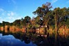
Lianshulu Lodge and its smaller sister property Bush Lodge enjoy unique locations amongst pristine and untouched wilderness.
Superb volume of game – the Kwando River teems with elephant, buffalo, hippo, lion, leopard, zebra, giraffe and many species of antelope – especially Roan and Sable.
Small boutique accommodation with an attentive and personal style of hospitality and yet not overly expensive.
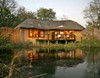
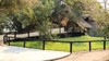
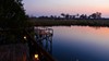
Location
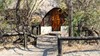
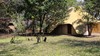
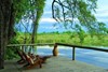
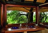
Located on an 800 hectare exclusive private concession inside the Mudumu National Park in North Eastern Namibia, on the famed Kwando River. Lianshulu is nestled under a canopy of riverine forest and its surroundings consist of open savannas, bushveld, wetlands and Kalahari woodlands.
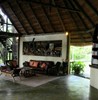
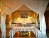
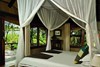
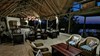
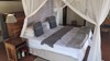
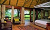
Guest Accommodation
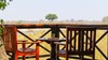
Lianshulu has 12 guest rooms in total, all with private decks.
Two guide rooms available.
In-room safe in every room.
Bush Lodge has 12 guest rooms in total with en suites.
All rooms have ceiling fans, gauze screen doors and mosquito netting and are comfortably and tastefully furnished.
Full Board and Dinner, Bed and Breakfast rates available.
All alcoholic beverages included in the full board option with the exception of premium brands.
Climate
Rainy season: Mid November to March.
Dry season: April to November.
Temperature: High 48°C in November to December and coolest 20°C in June and July.
Lodge closure: January. Lianshulu lodge & bush lodge fact sheet.
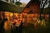
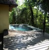
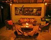
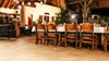
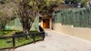
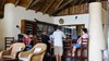
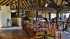
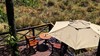
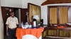
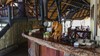
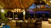
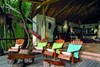
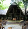
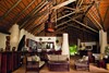
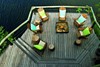
Guest Area
The main Lodge areas are designed for relaxation and comfort.
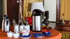
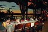
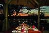
Delicious meals are served in various dining areas, at carefully sited individual tables.
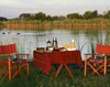
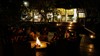
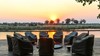
A firepit is lit every evening as guests sit under the clear star-filled African sky, at the end of a day like no other.
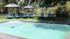
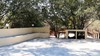
A swimming pool for the enjoyment of guests is situated near the main area.
Guests' Safety and Welfare
All guests are automatically covered by a medical rescue policy that covers evacuation to the nearest appropriate medical facility.
Lianshulu Lodge is not fenced thus Elephants do manage to frequent the property, along with hippos, buffaloes and even Lion and Leopard from time to time.
Safari and Activities
The Lodges offers early morning and afternoon game drives in open all-wheel drive vehicles through the Mudumu National Park, as well as guided walks in the lodge vicinity and selected areas of the park.
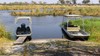
Boat cruises are also on offer during the mornings after sunrise and in the afternoons until sunset, for game viewing and birding on the Kwando River.
Fishing on a catch-and-release basis is also an activity that is readily available. All our activities are accompanied by an experienced and knowledgable guide.
A visit to a traditional tribal village.
Refreshments are served on all our activities
Additional Information
Number of Rooms:
Lianshulu Lodge: x12 rooms / 24 guests
Bush Lodge: x12 rooms / 25 guests
Amenities
Cellular coverage:
Telephone Cellular coverage not guaranteed / reception is poor
Disability:
Suitable for disabled guests: 1 room at Lianshulu Lodge & 1 room at Bush Lodge
Power:
Lianshulu Lodge: 12v at rooms, with 220v at reception.
Bush Lodge: 220v at rooms.
4x4 Transport:
Private 4x4 safari vehicle available at additional cost and subject to availability.


Cliff Jacobs (Nat Dpl Hotel Man (UJ). MPRE. GA Level 5 TEFL) Managing Principal / CEO Exquisite Hotel Consultants (Pty) Ltd Mobile: +27 (0) 84 413 1071 / +27 (0) 61 716 6951 Email: cliff@exquisitehotelconsultants.com Web: https://www.exquisitehotelconsultants.com © All rights reserved Terms and Conditions apply Scroll down to view our Hospitality Properties and Businesses for sale or lease or lease-to-buy or partnership arrangement or management agreement arrangement.